Re-organized and improved categories
OpenStreetBrowser's main categories got a few improvements:
OpenStreetBrowser's main categories got a few improvements:
OpenStreetBrowser is built from a bunch of modules (e.g. LeafletJS, TurfJS, ...; see the full list) - as most current web applications are. A few of them are written by me (e.g. overpass-layer). And one of them - overpass-frontend - has just gotten more intelligent.
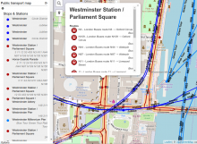
Before starting my project OpenStreetBrowser (which was a long time ago in autumn of 2008) I just wanted to create a public transport map (short: PT map). Creating a PT map is really difficult and creating a usable map is even more difficult. There are several reasons for this, including that OpenStreetMap itself adds a lot of complexity. But it is possible. Back then, my efforts resulted in OpenStreetBrowser 1, but the PT map code didn't last long.
Having all these categories in OpenStreetBrowser is a great thing. But creating these categories has been a work mostly done by me and I can't really guess which categories would be interesting to you. That's why I want other people (especially You!) to have the ability to create or improve categories yourself. That's why there's now a "More categories" link in OpenStreetBrowser, where you can access categories which other people (or You!) created or modified.
Finally, I re-implemented a feature of the old OpenStreetBrowser which I was especially proud of (although it's rather easy to implement): The Wikipedia integration.
Many OpenStreetMap features have links to Wikipedia articles and images. In the detailed view, OpenStreetBrowser will show the first paragraph and the first image of this article - in your preferred language (to be exact, the "data" language - you can set it in the Options). It loads the list of availble translations from the Wikipedia article itself.
Also, if any images can be found, these will be displayed.
A requested feature: Permalinks. OpenStreetBrowser URLs now encode the current map location, opened categories and - of course - the currently viewed map object. Now it's easy to share information to others.
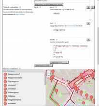
Popups of map features are now much more detailed. A lot of tags (like website, contact email, opening_hours, ...) are parsed, regardless of their category. If a tag is not set, nothing will be shown in the popup. Some information though (like the "cuisine" tag in the screenshot) are not generally parsed, but are restricted to the category.
Example of a gastro object:
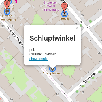 Before this improvement |
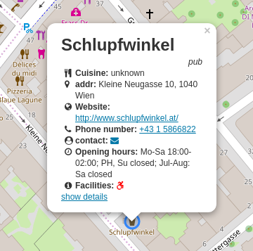 After this improvement |
If you want to see how this works, check the file openstreetbrowser-categories-main/popupBody.html. There's also a openstreetbrowser-categories-main/detailsBody.html for the information in the sidebar. Pull requests (or feature suggestions) for improvements and extensions are very welcome!
The files use the TwigJS template language.
This change is heavily inspired by Bexhill-OSM.
Incredible! OpenStreetBrowser is back. Not all categories have been ported to the new system yet, but many are already working :-) It uses Overpass API as backend (per default overpass-api.de) and Leaflet as frontend. It shares a lot of code with my public transport map.
If you want to have a look at the code, here are the sources:
One of my servers crashed due to a broken harddisk, therefore you have to live with a very reduced version of OpenStreetBrowser - there are no categories right now. You may still enjoy the background rendering ;) I'm currently in the process of building a new base for the OpenStreetBrowser: Categories written in MapCSS, using Overpass API as database and pgmapcss for processing. Also for displaying, the new OpenLayers ol3 will be used. The rewrite is already quite advanced, but still I need another month or two until the version can go online. Stay tuned!