Category update: maxspeed
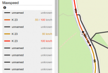
User mahdi1234 pointed out, that roads which have different maxspeed tags for each direction (tags maxspeed:forward and maxspeed:backward) would be regarded as "unknown" by OpenStreetBrowser. From now on the car maxspeed and railway maxspeed categories handle these tags. Forward maxspeed will always be shown to the right of the way, backward to the left.